Arizona Well Drilling LLC
HydroScan™ – Advanced Subsurface Water Mapping
Powered by Blue Core Geo
- Locating aquifers using HydroScan™ imaging.
- Drilling precisely to the identified water zone.
- Constructing and completing the well for long-term performance.
What Is HydroScan™?
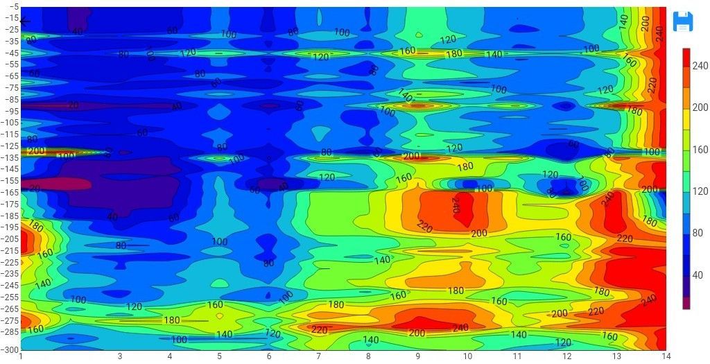
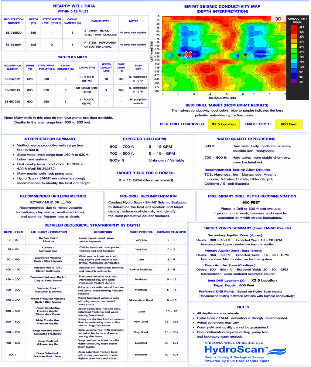
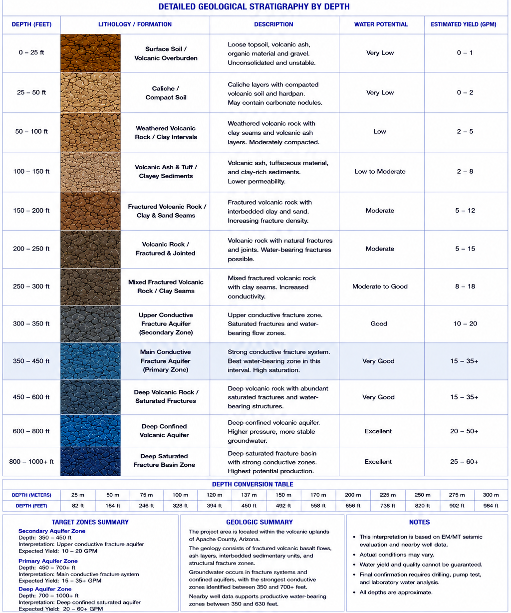
At Arizona Well Drilling LLC, we use HydroScan™, powered by Blue Core Technologies, to “see” beneath the surface and locate the most promising groundwater sources before drilling. HydroScan™ transmits controlled acoustic energy into the ground and analyzes how it travels through various layers, providing detailed images of subsurface structures and aquifers.
Understanding How the Seismic TESTING Process Works
Different Types of HydroScan™ Surveys
1. Shallow HydroScan™ Surveys – Ideal for detecting near-surface aquifers, fractures, and overburden conditions.
2. Deep HydroScan™ Surveys – Designed to map deeper water-bearing formations and identify geological structures influencing groundwater movement.
Resistivity Methods – Introduction
Surface electrical resistivity surveying measures how electrical current flows through different layers of soil and rock. When combined with HydroScan™ data, it delivers a complete and accurate picture of subsurface hydrogeology, ensuring the best possible drilling results.

How to Get Your Well Drilled Without Getting a “LEMON”
Imagine spending $30,000 or more on a well that produces no water. That’s like buying a car that turns out to be a lemon. With HydroScan™, we remove the guesswork and help you drill smarter — ensuring your investment yields a reliable, high-producing water source.
Minimize The Guesswork in Well Drilling
Most drillers rely solely on old well records or local assumptions about where water might be found. At Arizona Well Drilling LLC, we use HydroScan™ imaging to map groundwater structures before drilling starts, eliminating uncertainty and reducing costly mistakes.
Drilling is a major investment, and HydroScan™ ensures you make it wisely. By combining advanced imaging with decades of field experience, we deliver:
- Precision Water Mapping – 95% accuracy in locating the best drill sites.
- Cost-Effective Solutions – Avoid spending $25,000–$70,000 on a dry hole.
- Reliable Results – Scientifically verified data for confident drilling.
Subsurface Characterization with HydroScan™
Our HydroScan™ imaging and geological survey process provides unmatched precision in mapping aquifers, subsurface formations, and water pathways — ensuring every drilling project is successful and efficient.
Why HydroScan™ Is Essential
HydroScan™ helps us:
- Identify underground aquifers and fractures
- Reduce risk and eliminate costly guesswork
- Deliver long-lasting, high-yield wells
- Support responsible environmental and land-use planning
This technology-driven approach ensures reliable results and long-term well performance.
Expertise in Geological Surveys
Our experts conduct geological surveys across Arizona to guide every project with scientific accuracy. These surveys help determine soil composition, rock layering, and groundwater movement — critical factors for:
- New well construction
- Agricultural irrigation systems
- Commercial site development
- Environmental studies and compliance
Technology That Sets Us Apart
By combining HydroScan™ imaging, aquifer mapping, and precision drilling, we deliver superior results with guaranteed performance. Our integration of engineering expertise and advanced technology keeps Arizona Well Drilling LLC at the forefront of the water well industry.
Drill Rig Rental & Industry Inquiries
While drill rig rental is no longer our primary service, our global reputation for reliability continues to generate inquiries and partnerships from drilling professionals worldwide — reinforcing our position as leaders in HydroScan™ subsurface technology.
How Wells & Aquifers Actually Work
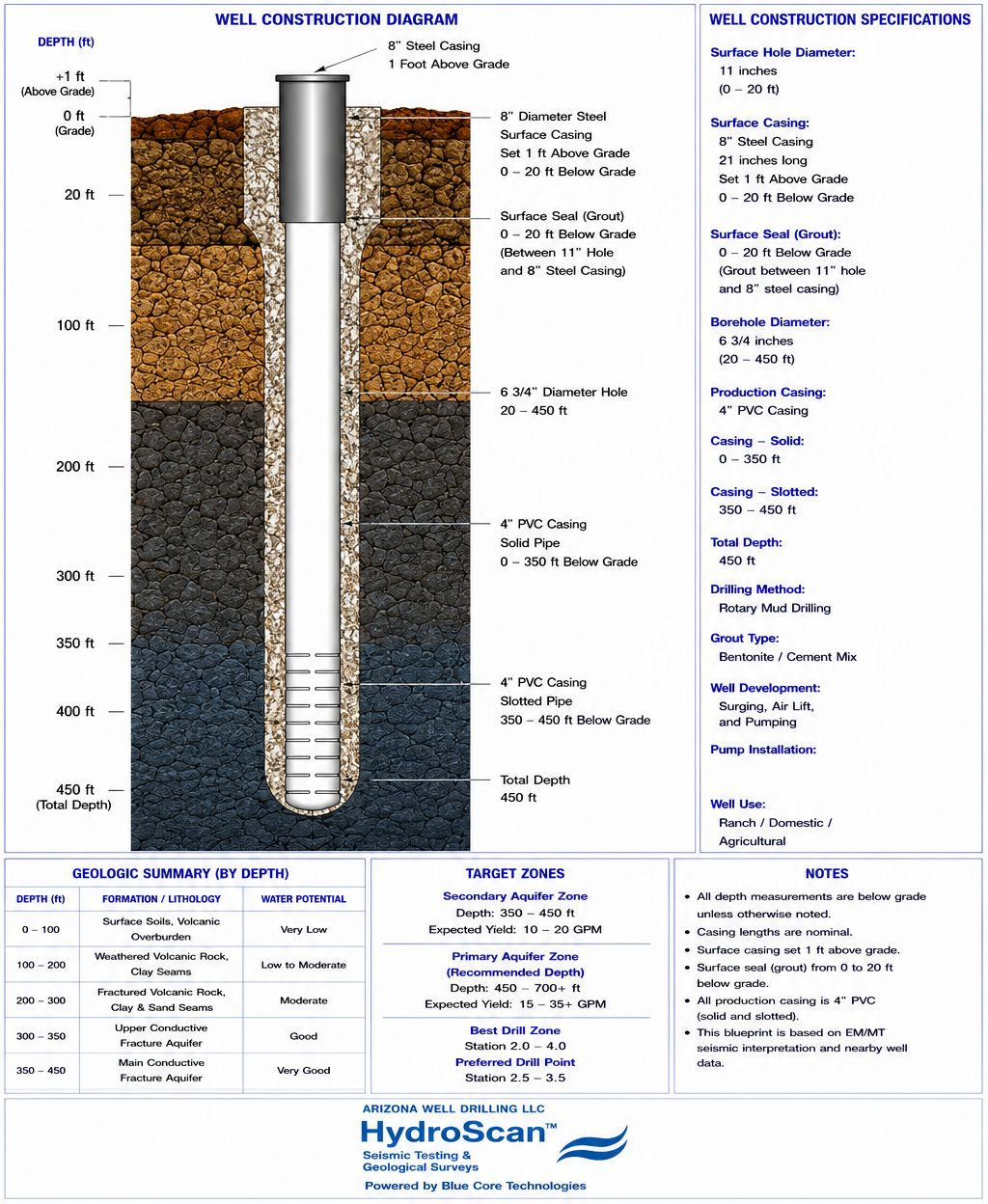
Wells tap into underground aquifers — natural formations of rock, sand, or gravel that hold groundwater. With HydroScan™, we pinpoint these aquifers with scientific precision, ensuring your well delivers the highest possible yield.
Our SEISMIC DATA - WHAT YOU CAN EXPECT
Our Process:
1. Locate aquifers using HydroScan™ imaging.
2. Drill precisely to the identified water zone.
3. Construct and complete the well for long-term performance.
The Arizona Drilling Advantage
Choosing Arizona Well Drilling LLC means partnering with a company known for:
- Proven results through HydroScan™ technology
- A flawless track record in well drilling
- Experience in residential, agricultural, and commercial projects
- Commitment to innovation and customer satisfaction
Can I Drill a Well on My Property?
Yes — and we can guide you every step of the way. Drilling requires permits and compliance with Arizona Department of Water Resources (ADWR) regulations. Our team assists with:
- The Notice of Intent to Drill (NOI) filing process
- Understanding water rights and property regulations
- Ensuring sustainable, compliant, and efficient well construction
Residential, Commercial & Agricultural Wells
We provide tailored well solutions for every need:
- Residential wells – Reliable water for homes and private properties
- Commercial wells – For industrial and business applications
- Agricultural wells – Supporting irrigation and livestock operations
Don’t Gamble with Your Well — Drill Smarter
Avoid costly mistakes. Let HydroScan™ show you exactly where to drill for the best water yield. Call (602) 830-1588 today for a free consultation and secure your water source for years to come!